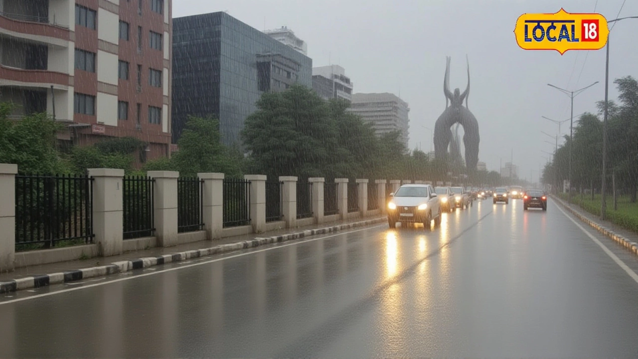
When India Meteorological Department (IMD) raised an orange alert on October 6, 2025, residents of Haryana braced for an unexpected bout of heavy rain, thunderstorms and even hail. The warning stems from a powerful western disturbance that has surged across northwest India, dragging moisture from the Arabian Sea and a cyclonic circulation perched over northeast Afghanistan and Pakistan.
What’s behind the western disturbance?
The disturbance is essentially a high‑altitude trough that forms in the upper tropospheric westerlies. Satellite imagery shows a deep cyclonic low hovering between 3.1 and 5.8 km above mean sea level, with a pronounced trough stretching along longitude 69°E north of latitude 23°N. This setup acts like a conveyor belt, pulling in warm, moist air from the Arabian Sea and dumping it over the Indo‑Gangetic plains. Meteorologists say the system’s steering currents are being nudged by a subtropical jet, which is why the rain band is marching eastward at a brisk pace.
Rainfall and hail forecast for Haryana
IMD’s bulletin predicts isolated heavy showers over the state’s key districts on Monday, with the possibility of hailstones in Chandigarh, the joint capital of Punjab and Haryana, as well as in Panchkula and Rohtak. Most districts will see 20‑40 mm of rain, while isolated pockets could exceed 60 mm. Thunderstorms are likely, with lightning flashes and gusty winds clocking 30‑50 km/h. Temperatures will linger around a high of 33 °C and a low of 22 °C, noticeably below the seasonal norm.
How authorities are responding
In the official bulletin, Dr. Shashi Kant, Scientist ‘D’ at National Weather Forecasting Centre, emphasized the need for vigilance. \"Citizens should avoid non‑essential travel, secure loose objects and stay tuned to local alerts,\" he warned. Local municipal bodies have pre‑positioned sandbags in flood‑prone zones and dispatched rapid‑response teams to clear drainage channels. Schools in the most affected districts have been advised to remain closed until evening, and the Haryana Disaster Management Authority (HDMA) is monitoring river levels around the Yamuna tributaries.
Potential impact on daily life
For commuters, the rains translate into slippery highways and delayed trains, especially on the Delhi‑Kalka line that threads through Panchkula. Farmers in the Rohtak and Jind districts are hoping the showers will replenish soil moisture after a dry spell, but sudden hail could damage early‑season crops like mustard and wheat. Power utilities have issued cautions about possible short‑circuits, and mobile networks reported brief outages in rural pockets as towers swayed under gusty winds.

What’s next? Outlook through October 9
By October 7, the western disturbance is expected to lose its intensity, with rain tapering to light to moderate showers across most of Haryana. The storm system will drift further east, sparing the state from another round of heavy precipitation. However, the cooler night temperatures—averaging 22 °C—will linger, making evenings feel unusually chilly for early October. IMD projects a return to normal weather patterns by October 9, but officials urge residents to stay alert until the system fully dissipates.
- Orange alert active for Haryana, Jammu & Kashmir, Punjab, Himachal Pradesh, Uttarakhand, and Rajasthan.
- Expected rainfall: 20‑60 mm, with isolated hail in Chandigarh, Panchkula, Rohtak.
- Wind gusts up to 50 km/h; lightning likely.
- Maximum temperature: 33 °C; minimum: 22 °C.
- Weather normalisation anticipated by October 9.
Frequently Asked Questions
How will the rain affect commuters in Haryana?
Roads, especially the National Highway 44 corridor, may experience waterlogging and reduced visibility. Train services on the Delhi‑Kalka line have been delayed by up to 30 minutes, and local bus operators advise passengers to allow extra travel time.
What agricultural crops are most at risk from hail?
Early‑season mustard and wheat, which are sprouting across Rohtak and Jind, are vulnerable. Hailstones can shred young seedlings, potentially trimming yields by 5‑10% if the storm intensifies.
Is the orange alert different from a red alert?
Yes. An orange alert signals a high likelihood of severe weather that could cause disruptions, whereas a red alert denotes an imminent or ongoing event with a high probability of significant damage or loss of life. The current situation warrants heightened caution but not yet an emergency response.
When is the weather expected to return to normal?
IMD forecasts that by October 9, 2025, the western disturbance will have moved eastward, leaving Haryana with clear skies and temperatures comparable to the seasonal average.
What safety measures should residents take during the hailstorm risk?
Stay indoors, keep windows closed, secure outdoor objects that could become projectiles, and avoid driving unless necessary. Keep a battery‑powered flashlight and emergency supplies handy in case power outages occur.